I am not a mountaineer. I jog occasionally, badly. I own hiking boots but have no technical climbing experience. I took the stairs instead of the lift for two weeks beforehand and considered this preparation. I summited Jbel Toubkal (4,167m) in two days.
Let me be clear about what this means and what it doesn't. Toubkal requires fitness, altitude awareness, and the right conditions. It does not require technical skills, specialised gear, or prior high-altitude experience (in summer). Thousands of people summit every year, including many who, like me, are enthusiastic amateurs rather than serious mountaineers.
The Route — A 2-Day Overview
Day 1 — Imlil to the Refuge (1,467m gain)
Start in Imlil (1,740m), reachable by grand taxi from Marrakech in 1.5 hours (80 MAD shared, or 400 MAD private). The village has several cafés and a trekking gear rental shop if you're missing anything.
The walk to the Refuge du Toubkal takes 4.5–5 hours. The first section passes through the Berber villages of Aroumd and Tinerhourhine — stone houses terraced into the hillside, walnut orchards, mules loaded with supplies. It feels ancient because it is.
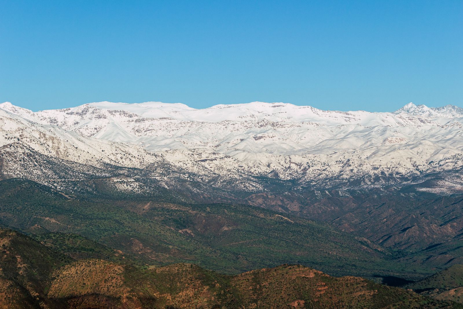
At Sidi Chamharouch (2,310m) is a small Amazigh shrine and a string of cafés. This is the last reliable water stop — fill bottles here. The path from here steepens, crossing boulder fields and scree. The views open progressively westward as you climb.
The Refuge du Toubkal (3,207m) is a substantial mountain hut run by the Club Alpin Français. Dorm beds, reasonable meals (tagine or omelettes), hot tea, limited showers. Book ahead June–September — it fills quickly. The nighttime temperature here drops to around 5°C even in summer.
Day 2 — Summit Attempt
Leave the refuge at 6am. Dawn breaks over the eastern ridge as you begin the ascent through the boulder field above the refuge. The path is marked with cairns and usually traceable even in poor visibility.
The south couloir — the main summit route — is a long, steep scree and loose rock slope that requires about 1.5 hours of slow, deliberate climbing. In summer (June–September) no technical equipment is needed. In winter and spring, crampons and ice axe are mandatory and only experienced alpinists should attempt it.
The summit plateau arrives with startling suddenness after the couloir. You step up from the scree and the entire Atlas range is suddenly visible in all directions. On a clear day: the anti-Atlas to the south, the Atlantic haze to the west, the Saharan transition to the east. The summit cross marks the highest point in Morocco and North Africa (Kilimanjaro is higher for the continent). Most people sit for 30 minutes and can't bring themselves to leave.
Descent to Imlil: 4 hours. Total Day 2: 8–10 hours depending on pace.
Costs
Total realistic budget for 2-day trek: 1,500–2,000 MAD per person (~$150–200 USD) excluding international travel and Marrakech accommodation.
Essential Kit List
- Hiking boots — Ankle support essential. Rental available in Imlil.
- Trekking poles — Dramatically reduce knee strain on descent. Rental available.
- Warm layers — Temperature at 4,167m is 15°C colder than Marrakech. Even in August, a fleece and windproof jacket are needed.
- Headlamp — For pre-dawn summit departure. Bring spare batteries.
- Water — 3 litres minimum per day. Purification tablets if collecting from streams.
- High-calorie snacks — Nuts, chocolate, energy bars. Appetite decreases at altitude; caloric needs don't.
- Sun protection — UV intensity is extreme at altitude. Factor 50+ cream, sunglasses, hat.
Best Time to Go
- June–September: Best months. No snow, clear paths, no technical gear needed. Crowded July–August.
- May / October: Excellent shoulder season — fewer people, possible late/early snow on the summit slope (check conditions).
- November–April: For experienced alpinists only. Crampons and ice axe mandatory. Several deaths occur here each winter.
The Mental Side of the Climb
Nobody tells you about the last 300 vertical metres. The south couloir — the final approach to the summit — is long, loose, and demoralising in a way that the numbers don't prepare you for. Every step forward slides half a step back on the scree. The altitude is doing things to your breathing that feel disproportionate to the effort. The summit appears, disappears behind a ridge, appears again, seems no closer.
My guide, Ibrahim, had been up this mountain forty times. He walked twenty metres ahead at all times, never looking back, setting a pace that seemed slow until I tried to maintain it and found it was exactly right. He stopped every forty minutes, produced sweet mint tea from a thermos, said nothing, and let the altitude work itself out. This is the local guide method: they don't motivate, they don't encourage, they simply move at the correct pace and demonstrate by example that the summit is reachable because they have reached it dozens of times before.
At the summit cairn (4,167m) the world is genuinely different. Atlas ridges extend in every direction — white with snow in winter, grey-brown in summer. On a clear day you can see the Atlas Saharan foreland to the south. On an exceptionally clear day, you can see the Atlas Tellien in Algeria. This is Africa's second-highest peak after Kilimanjaro — you feel that.
The Imlil Village — Where It All Starts
Imlil (1,740m) deserves more than a transit stop. The village has grown significantly around Toubkal trekking but retains its agricultural identity — walnut orchards, terraced barley fields, the water channel (seguia) that irrigates the valley. Arrive the afternoon before your trek and walk the village paths at dusk when the light on the Atlas peaks is extraordinary and the muezzin call echoes off the granite.
The gear rental shop on the main square (there are now three — prices similar) rents: crampons, ice axes, trekking poles, gaiters, sleeping bags rated to -10°C. In summer you need none of this. In winter you need all of it. In spring and autumn, check conditions with your guide the day before — the snowline can drop overnight.
Accommodation: the guesthouses in Imlil charge 120–200 MAD per night for a private room with breakfast. The refuge du Toubkal (3,207m) charges 120 MAD per person in the dormitory (no private rooms) and serves dinner for 80 MAD. Book the refuge in advance during July and August — it fills.
Alternative Routes — Beyond Toubkal
Toubkal is the most famous Atlas trek but not the most interesting. Once you've done it, or if you want something less crowded:
- M'Goun Massif (4,071m) — The second-highest peak in the Atlas is accessed via the Aït Bou Guemez valley — Morocco's most beautiful agricultural valley. A 4–5 day circuit. Almost no other trekkers. Genuinely remote.
- Jebel Sirwa (3,304m) — Between the High Atlas and Anti-Atlas, this isolated peak is a 3–4 day trek from Taliwine. February/March sees a saffron harvest in the surrounding villages.
- Toubkal Circuit (4 days) — Rather than the out-and-back via the south couloir, a 4-day circuit takes you over the Tizi n'Ouanoums pass with views into the Aït Mizane valley before returning via Tachdirt village. More demanding, infinitely more rewarding.
- Day hikes from Imlil — Aroumd village (1.5h), Tacheddirt (4h), Ourika Valley (requires transport) — for those who want Atlas scenery without the Toubkal commitment.